All Things
 There is a temptation, though, to do mountain hikes, covered in woodland, to beautiful streams, so we did one on Sunday, the “Borrego Loop” off Hyde Park Road (which runs NE from Santa Fe to the ski area). Much of the Borrego Trail is downhill through forests of Ponderosa pine and tall aspens and some spruce and fir, down to the Tesuque Creek; the segment of Windsor Trail which forms the base of the triangle runs more down along the creek, and the Bear Wallow trail back is, thus, uphill. Close to 8000 feet and 36 hours from my baseline 400 feet in KC, it took a lot out of me! The book says a 760 foot gain, but I don't know if that is net or gross -- a lot of down also! I was ready for lunch (lovely) and a nap. Well, I’m almost always ready for a nap. That’s how I know it’s vacation! We’d done this before, with my sister and brother-in-law, in the snow of winter. Mountains have the advantage, compared with canyons, of being down on the way back, this one was a little different for hiking in the mountains. I also note that the book doesn't seem to care too much about total elevation gain; if it is not too steep and the trail is in good shape, it is "easy", as was this one.
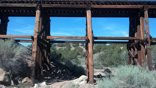 There is a trail along the railroad tracks just north of here; they run (and people bike it) into Santa Fe to the northwest; there is a tourist train, but also the Southwest Limited runs through Lamy, NM en route from Chicago to LA. Lamy is the closest stop to Santa Fe, so maybe there are a different set of tracks heading out of it to Albuquerque. Pat just took it from KC to Lamy overnight last week, but, of course, didn’t stay on to see where the tracks go this side of town. Anyway, there is a barbed wire fence along the tracks making it hard to get to overland, but the other night we discovered a trail that starts off the road across from us and winds through the desert to the tracks and an opening in the fence, where the bikers and hikers (us) can get through. Lovely walk; took the hiking poles even though I didn’t need them for balance on a basically level walk but it is apparently more exercise since you use your arms. Then walking along the rail trail, mostly right alongside, some up and downs where the tracks go through a narrower area, and some (for fun) walking along the rails (there I did use the poles for balance). Someone has put birdhouses all along the fence line, and at one point we came across a large patch of squash plants; blossoms but no fruit yet, and presumably, given the location, volunteers. The tracks go over a very pretty wooden bridge over a wash, and eventually cross US-285. There we turned south (using the poles as leashes for the dogs) a short ways to our own road and back about a mile and a half.
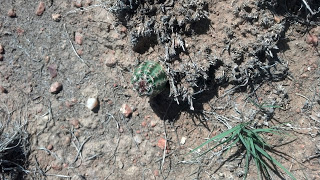 I notice, walking back the mile or so along the road in the direction we usually walk out on (coming back on a higher trail), two things. First, it is mostly uphill; going on an easy downhill is never so obvious. Second, there are a lot more mature piñon pines here than farther down the road, for some reason. At 6700 feet, our trees are almost all juniper and piñon, unlike the Ponderosa and aspen of the higher elevation, and lots of the piñon had died from bark beetle, drought making the trees’ defense (coating them in sap) more difficult. Over the last few years we’ve seen more piñon coming back, often in the shelter of protective junipers, but down the road there must be a microclimate that has had them surviving. I cut across our land, looking down because ground-hugging prickly pear look a lot like the other vegetation until you get close, and I see a tiny, one-inch high, hedgehog cactus. All the other cacti are prickly pear and cholla so it is a lovely surprise.
- Santa Fe April...fry And The Coyotes
Well, I’ve been in Santa Fe pretty continuously for more than 6 weeks, and have a routine. Wake, take dogs out (Fry on leash) for shortish hike, have breakfast, work, then maybe go to Eldorado to work out. Nap, work, take a longer hike. It is beautiful....
- Fry Dog: Too Smart For His Own Good!
So Pat just drove down to Santa Fe with the dog. It was going to be the dogs, and indeed started with the dogs, for oh, about 2 miles. To the gas station just west of the 18th Street Trafficway on Steele Road. Then she opened the back and Fry jumped...
- Dogs, The Lake And Hunting
So we hear that the city and county have decided to allow hunting around our lake. But take heart: they have decided to not allow rifles, only bow and shotgun! Phew! Of course, they are allowing it right up to the road, which I walk the dogs on all the...
- Cooler Summer Days At The Lake
Summer has cooled off in Kansas; after the hottest July ever, with very few days under 100, we had a lovely weekend last week at the lake. On Saturday, the high was in the 80s, with little breeze. Saturday morning I went kayaking. I wasn’t sure if...
- Christmas In Tucson
It is colder than you might have thought, or at least might have wanted. When my son arrived almost at midnight on the 22nd, it was less than 35 degrees; maybe not much colder than what he left in Chicago, but he was hoping for tropical paradise. A couple...
All Things
Santa Fe and the Pleasure of Flat Hikes
Four days into my vacation at our recently built small house SE of Santa Fe, and hopefully getting into a pace where I spend less time on work email and more on sitting out on the east deck in the early morning cool, sipping coffee and watching the hummingbirds with binoculars. I think that they are broad-tails, with deep green back; the majority would be females, though, without the scarlet neck. Most of the other birds seem to be some variety of sparrow. Our land and the surrounding Galisteo Basin Preserve is beautiful, and there are lots of trails on the ridges and in the basin; mostly more or less level after going down into it (and, of course, back up). Have done many of them, and on Friday night, when I arrived, we joined a group for a geology talk and hike describing the layers from a really long time ago to as recently as 45 million years ago!
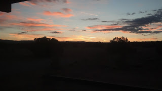
There is a temptation, though, to do mountain hikes, covered in woodland, to beautiful streams, so we did one on Sunday, the “Borrego Loop” off Hyde Park Road (which runs NE from Santa Fe to the ski area). Much of the Borrego Trail is downhill through forests of Ponderosa pine and tall aspens and some spruce and fir, down to the Tesuque Creek; the segment of Windsor Trail which forms the base of the triangle runs more down along the creek, and the Bear Wallow trail back is, thus, uphill. Close to 8000 feet and 36 hours from my baseline 400 feet in KC, it took a lot out of me! The book says a 760 foot gain, but I don't know if that is net or gross -- a lot of down also! I was ready for lunch (lovely) and a nap. Well, I’m almost always ready for a nap. That’s how I know it’s vacation! We’d done this before, with my sister and brother-in-law, in the snow of winter. Mountains have the advantage, compared with canyons, of being down on the way back, this one was a little different for hiking in the mountains. I also note that the book doesn't seem to care too much about total elevation gain; if it is not too steep and the trail is in good shape, it is "easy", as was this one.This morning got up early to see the sunrise, despite having been up late seeing La Traviata at the gorgeous outdoor Santa Fe Opera last night, have breakfast and hang around for the guys who work for the builder to get our eastern door open before going on the morning hike.
The house is glass on 3 sides (except north) but none of the windows open so the breeze comes through with the east and west doors open. The wind is from the west, so can blow the east door (hung inside) closed, so we had two rubber doorstops in it. A big enough gust came, however, to slam it closed hard, with the doorstops wedged into what should be a tiny potential space between metal door and sill, making it impossible to open. They used a couple of prybars to lift it from inside enough to pull the doorstops out from outside.
There is a trail along the railroad tracks just north of here; they run (and people bike it) into Santa Fe to the northwest; there is a tourist train, but also the Southwest Limited runs through Lamy, NM en route from Chicago to LA. Lamy is the closest stop to Santa Fe, so maybe there are a different set of tracks heading out of it to Albuquerque. Pat just took it from KC to Lamy overnight last week, but, of course, didn’t stay on to see where the tracks go this side of town. Anyway, there is a barbed wire fence along the tracks making it hard to get to overland, but the other night we discovered a trail that starts off the road across from us and winds through the desert to the tracks and an opening in the fence, where the bikers and hikers (us) can get through. Lovely walk; took the hiking poles even though I didn’t need them for balance on a basically level walk but it is apparently more exercise since you use your arms. Then walking along the rail trail, mostly right alongside, some up and downs where the tracks go through a narrower area, and some (for fun) walking along the rails (there I did use the poles for balance). Someone has put birdhouses all along the fence line, and at one point we came across a large patch of squash plants; blossoms but no fruit yet, and presumably, given the location, volunteers. The tracks go over a very pretty wooden bridge over a wash, and eventually cross US-285. There we turned south (using the poles as leashes for the dogs) a short ways to our own road and back about a mile and a half. I notice, walking back the mile or so along the road in the direction we usually walk out on (coming back on a higher trail), two things. First, it is mostly uphill; going on an easy downhill is never so obvious. Second, there are a lot more mature piñon pines here than farther down the road, for some reason. At 6700 feet, our trees are almost all juniper and piñon, unlike the Ponderosa and aspen of the higher elevation, and lots of the piñon had died from bark beetle, drought making the trees’ defense (coating them in sap) more difficult. Over the last few years we’ve seen more piñon coming back, often in the shelter of protective junipers, but down the road there must be a microclimate that has had them surviving. I cut across our land, looking down because ground-hugging prickly pear look a lot like the other vegetation until you get close, and I see a tiny, one-inch high, hedgehog cactus. All the other cacti are prickly pear and cholla so it is a lovely surprise. By now, it is getting warm, but it has been a lovely hike, and I’m not completely wiped out by climbing up and down. There is a lot to be said for level hikes!
- Santa Fe April...fry And The Coyotes
Well, I’ve been in Santa Fe pretty continuously for more than 6 weeks, and have a routine. Wake, take dogs out (Fry on leash) for shortish hike, have breakfast, work, then maybe go to Eldorado to work out. Nap, work, take a longer hike. It is beautiful....
- Fry Dog: Too Smart For His Own Good!
So Pat just drove down to Santa Fe with the dog. It was going to be the dogs, and indeed started with the dogs, for oh, about 2 miles. To the gas station just west of the 18th Street Trafficway on Steele Road. Then she opened the back and Fry jumped...
- Dogs, The Lake And Hunting
So we hear that the city and county have decided to allow hunting around our lake. But take heart: they have decided to not allow rifles, only bow and shotgun! Phew! Of course, they are allowing it right up to the road, which I walk the dogs on all the...
- Cooler Summer Days At The Lake
Summer has cooled off in Kansas; after the hottest July ever, with very few days under 100, we had a lovely weekend last week at the lake. On Saturday, the high was in the 80s, with little breeze. Saturday morning I went kayaking. I wasn’t sure if...
- Christmas In Tucson
It is colder than you might have thought, or at least might have wanted. When my son arrived almost at midnight on the 22nd, it was less than 35 degrees; maybe not much colder than what he left in Chicago, but he was hoping for tropical paradise. A couple...